During the last week of April, I took 13 students from
Coconino Community College on a six-day field trip to the Henry Mountains in Utah (GLG 298). It is a very unique area that is remote, little visited, and full of surprises. We explored the Mt. Hillers stock, the Waterpocket Fold in Capitol Reef, some nearby slot canyons, and other geo-gems along the way. Take a look.
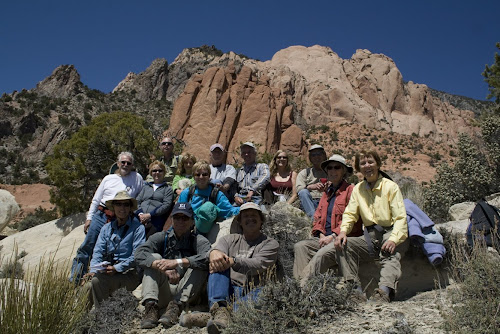

Here we are, the 14 of us outside the Mt. Hillers stock for a group shot. We are seated on an upturned, vertical fin of sandstone within the Jurassic Morrison Formation.
Mt. Hillers is the middle of five separate laccolithic intrusions. These features are not volcanic but rather were intruded into the sedimentary rocks as sills, which later became inflated into subsurface domes.

Our target on the first day was to visit the very place where the beds of sandstone were upturned by the intrusion. The red beds are Wingate and Navajo Sandstone.
My goal for the class was to hike into the upturned beds and visit the contact of a sill with the redbeds. It was very tough going on an off trail route but we managed to find it. Note the students climbing in the lower part of the photo.

Here we are taking a short rest at the contact. Somewhat surprisingly contact metamorphism is not prevalent in these types of intrusions.

Jean admires the power of magma to upturn beds of sandstone
After completing the hike, we drove around Mt. Hillers on a loop road through Stanton Pass. Here is a view of Mt. Ellen, the highest peak in the Henry Mountains at 11,522 feet.
Along Straight Creek we saw our first outcrop of the Summerville Formation. Its even bedding makes it one of the most attractive units on thew whole Colorado Plateau.

Starting out on the second full day of the trip, we drove on the Egg Nog Road to the southwest of Mt. Hillers. The Henry structural basin displays Cretaceous rocks like these.

We passed an oyster shell reef within the Dakota Sandstone and stopped to take a look. These are from a species known as Gryphea newberryi, common name "Devil's toes."
Beautiful exposure of the Mancos Shale capped with the Ferron Sandstone near the southeastern edge of Capitol Reef National Park.
The great Waterpocket Fold in Capitol Reef National Park. Crustal compression during the Laramide Orogeny (70 to 40 Ma) caused the once flat-lying strata to become bent or folded into this spectacular structure. Beds from the Triassic Moenkopi Formation (top right) to the Jurassic Morrison Formation (left cliff) are exposed in this view.
There is a trail that leads down into Hall's Creek and we took the 800 foot plunge.
Along the way we observed very coarse conglomerates in the Salt Wash Member of the Morrison Formation.
These clasts were derived from mountains to the west and south in late Jurassic time and the dinosaurs found these river environments to their liking.

Next on our list was a trip to the Burr Trail, an old uranium haul road from the 1950's that climbs the Waterpocket Fold. Note the road visible in the lower sections of the photo.
Most folks just drive the Burr Trail but geology students want to walk the route (downhill of course) to view the wonderful geology. Here students inspect the contact between the lower Kayenta Formation and the capping Navajo Sandstone.
On the way back to camp, we took the southern extension of the Burr Trail into the Glen Canyon National Recreation Area. The road followed a high ridge between Hall's Creek and Bullfrog Creek seen here. It was an amazing drive! The bright orange unit near the creek bed is the Jurassic Entrada Sandstone, and it is capped by the banded Summerville Formation and the Morrison Formation.
Day three saw us exploring some slot canyons on the east side of the Henry's. This is Butler Canyon just east of North Wash.

Mary Lea is checking out this channel that was cut within the Kayenta Formation. Note the lower bed of sandstone and the channel-form she is sitting on. The deposits within the channel have wonderful examples of mud rip-up clasts.

This is a close-up of some rip-up clasts in the fluvial Kayenta Formation. We saw mudstone in place that had filled stream channels. Later, this mudstone was ripped up to yield mud clasts like those seen above. It was real dynamic.

Gisela found these ripple marks in an eroded bed of Kayenta Formation

Students walking along the cross-beds in the Navajo Sandstone
We found a slot canyon and hiked up into it

This was our lunch spot in the canyon
 A scene from the awards dinner. From left, Kathryn Conrad and Holly Schaffer, both of the University of Arizona Press, and Gwen Henson, the Executive Director of the Arizona Book Publishers Association.
 Here I am with the first Glyph for "Images"
 Helen Thompson accepted the award for "Ancient Landscapes" on behalf of the Grand Canyon Association
 Wayne and Helen with two of the three trophies
 Glyph Awards, 2009


