Wednesday, June 30, 2010
GIant Whale Fossil Found in Peru
Researchers were recently working in the desert badlands of coastal Peru and unearthed the skull of a giant toothed whale. The deposits that held the skull were middle Miocene in age (about 12 million years ago) and the teeth were enormous. Follow this link for pictures, diagrams and a short video by the head researcher. Wow!
Monday, June 28, 2010
Schultz Fire Mostly Contained; Fantastic Movie of Landslide in Italy
The Schultz fire here in Flagstaff is now 60% contained and crews are just mopping up.
But look at this movie of a landslide that happened in Italy this past January. It is fantastic.
But look at this movie of a landslide that happened in Italy this past January. It is fantastic.
Saturday, June 26, 2010
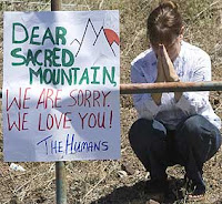
Other Blog Photos of the Scultz Fire
Friends have been finding and passing along some good blogs and photos about the fire here. Check this one out. Imagine taking a hike to Humphrey's Peak and seeing it blow up right in front of you.
Looks like the fire is getting into the mop-up stage now. 50% containment and some crews moving out to the next flare-up somewhere out west.
Looks like the fire is getting into the mop-up stage now. 50% containment and some crews moving out to the next flare-up somewhere out west.
Thursday, June 24, 2010
New Shots of the Schultz Fire

From 39,000 feet. The red X is where Wayne and Helen's house is. Thanks to whoever sent these.
 It looks like the Peaks are on fire here but it is the hlls east of them.
 Same here.
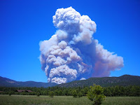
 Map of the burn area and the days it torched. Blue June 20, Pink June 21, Red June 23, orange June 24
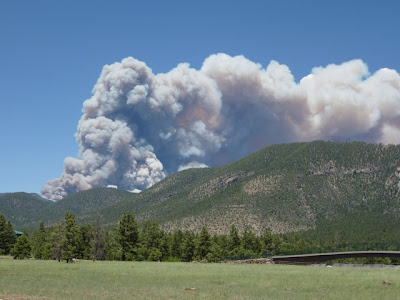
 Like a volcano! (Photo by Lorraine B. Elder)
Tuesday, June 22, 2010
Update on the Schultz Fire
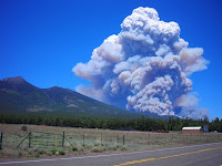
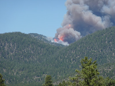
We hear the tanker planes and helicopters flying overhead as they battle the fire. It is at 12,000 acres and counting. One of our citizens says it best below.
 The following pictures are from Chuck LaRue and give you a sense for how this thing "blew up" on Sunday. Helen and I were driving back from Prescott while this was the scene.
 The wind just grabbed it.
 And fanned it hard.
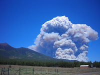 And then it multiplied.
 And all anyone could do was get out of the way.
 The following pictures are from Chuck LaRue and give you a sense for how this thing "blew up" on Sunday. Helen and I were driving back from Prescott while this was the scene.
 The wind just grabbed it.
 And fanned it hard.
 And then it multiplied.
 And all anyone could do was get out of the way.
Sunday, June 20, 2010
Additional Fire Photo from Winslow - 55 miles Away
A fire this size creates its own weather from sucking in oxygen. It's massive and consuming all in its path.


Fire in Flagstaff
Many of you have been asking about the fires erupting in Flagstaff (they have made the national news). We are fine - both fires are blowing away from us but there are many people in danger on losing homes on the east side of town. My friend sent these pictures from Wyoming (I don't know how her got them but that's just the way the web works these days. Most likely he has a friend here who uploaded them to him and he e-mailed them to me).
I wanted to take pictures with my camera but it went on the blink today and was too frazzled to understand that I needed to change the battery. Anyway, the Hardy fire (June 19) is mostly under control but Helen and I were up on Mars Hill yesterday and watched 200 foot flames consume whole Ponderosa pine trees. It was powerful. As it was blowing right towards east Flagstaff, they put a lot of resources on it and the wind died down overnight. Then, while we were away in Prescott giving a lecture, the Schultz fire erupted (June 20). It is a monster and the photo's below show that. These flames are most likely 250 feet high.
We were camping last July 1 with some high school friends where this one is burning right now. We are fine but concerned for friends who live out east of here.
 From Cedar Hill looking north to Mt. Elden.
 Same road different angle
 Cedar Hill view
 Get out of the way - this is hot and out of control.
 Dry Lake Hills burning
 We'll let you know more later but right now it's our anniversary!
Monday, June 14, 2010
A One Year Anniversary
After celebrating the 100th anniversary of Rainbow Bridge, Helen and I are ready to celebrate a more modest milestone this week - our one year wedding anniversary! It's been a great year for both of us. The economic downturn couldn't have come at a better time - all of my fancy trips overseas did not happen this year. I got to stay in the United States and be with my sweetie! Thank you greedy-housing-bubble-aficianados! Here are few pictures of our year.
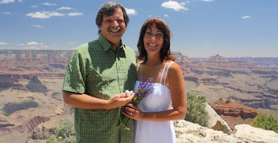
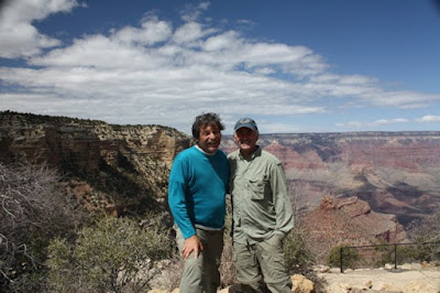
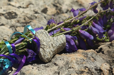 A picture from our wedding day at "Ranney Point" on Grand Canyon's South Rim. The flowers Helen picked on the way to the wedding and the heart rock is from the Mt. Everest Base Camp where I proposed to her.
 Our pre-wedding parties overlapped for one night in San Diego. My friends gave me the best bachelor party I could ever hope for - a one week road trip through the Southwest!
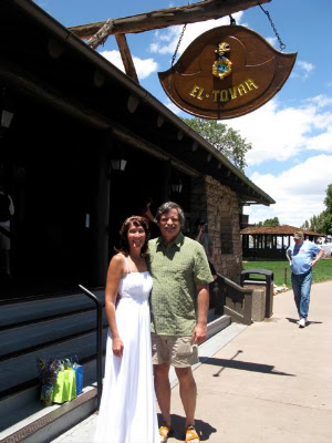 On our honeymoon at the El Tovar. We had the Presidential Suite which was unbelievable!
 High school friends Chris, Orlando, Vince and Wayne at our reception, Ten-X Campground June 28, 2009.
 The article that ran on the front page of the Sedona Red Rock News about our engagement.
 Helen with her bridesmaid, Barbara Denny at "Ranney Point"
 The happy couple celebrates, June 21, 2009
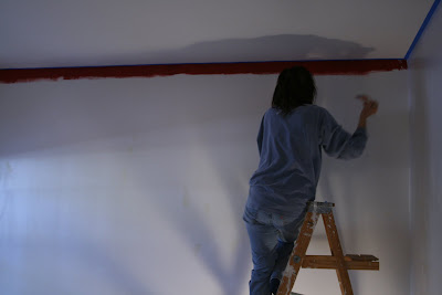 Helen gets our guest room ready for a new paint job.
 Wayne doing the same.
 Our first Valentines Day dinner as a married couple
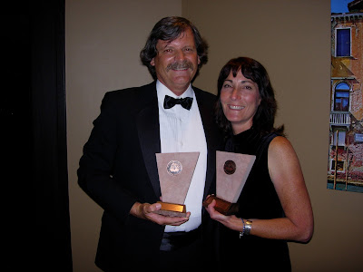 At the Arizona Book Publishers Award Ceremony in Phoenix, May, 2009.
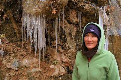
In the Zion Narrows, December, 2009. We went up here while I gave a lecture to the Zion Natural History Association.
 A crazy picture with my Best Man Don Webster, on a hike down to Phantom Ranch, March, 2009.
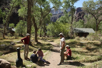 With Don Webster's family at Phantom Ranch.
 A picture from our wedding day at "Ranney Point" on Grand Canyon's South Rim. The flowers Helen picked on the way to the wedding and the heart rock is from the Mt. Everest Base Camp where I proposed to her.
 Our pre-wedding parties overlapped for one night in San Diego. My friends gave me the best bachelor party I could ever hope for - a one week road trip through the Southwest!
 On our honeymoon at the El Tovar. We had the Presidential Suite which was unbelievable!
 High school friends Chris, Orlando, Vince and Wayne at our reception, Ten-X Campground June 28, 2009.
 The article that ran on the front page of the Sedona Red Rock News about our engagement.
 Helen with her bridesmaid, Barbara Denny at "Ranney Point"
 The happy couple celebrates, June 21, 2009
 Helen gets our guest room ready for a new paint job.
 Wayne doing the same.
 Our first Valentines Day dinner as a married couple
 At the Arizona Book Publishers Award Ceremony in Phoenix, May, 2009.
In the Zion Narrows, December, 2009. We went up here while I gave a lecture to the Zion Natural History Association.
 A crazy picture with my Best Man Don Webster, on a hike down to Phantom Ranch, March, 2009.
 With Don Webster's family at Phantom Ranch.
Monday, June 07, 2010
The 100th Anniversary of Rainbow Bridge National Monument
Question: "What's the difference between the English and Americans?"
Answer: "The English think 100 miles is a long way and Americans think 100 years is a long time."
On May 28 to 30, 2010, I was privileged to experience both an English and American view of life as I took part in honoring 100 years for Rainbow Bridge National Monument. I traveled 100 miles (round trip) in a boat to this impressive natural archway, which was created in 1910 by the Presidential proclamation of the infamous William Howard Taft. I was accompanied during this memorable weekend by my lovely wife Helen and our great friend Gary Ladd of Page.
The festivities began on Friday evening, May 28. I presented a lecture, "Ancient Landscapes of the American Southwest" to about 130 people at the Carl Hayden Visitor Center. Chris Eaton, director of the Glen Canyon Natural History Association, estimated that this was the largest crowd ever for a lecture in the rotunda room. It was a rousing success as I shared the secrets of earth history and the Colorado Plateau with an engaging audience. The lecture was my second as an Arizona Road Scholar, under the auspices of the Arizona Humanities Council. This is a wonderful program that puts speakers in front of audiences statewide.
On Saturday, May 29, we hopped in a boat and traveled 50 beautiful miles to Forbidding Canyon and Rainbow Bridge National Monument. Here we met many of the superintendents of the southwestern parks who were also here to celebrate in the commemoration. A big warm thank you to everyone in Page who made this event so special. This includes Joan Mayer, interpretation coordinator for Glen Canyon National Recreation Area and superintendent Stan Austin. Have a look at some of the pictures!
 Gary and Helen viewing the terrain as we proceed up the lake to Forbidding Canyon. Fortunately, the wind was not howling for the first time in many days.
 Gary and Helen at the dock in Forbidding canyon.
 Gary is best known as an accomplished photographer of Lake Powell. But he is also a gifted and self taught geologist and knows the country here very well. Here he is showing Helen the contact of two rock formations, the Kayenta Formation below which is overlain by the Navajo Sandstone. This contact played a big role in the creation of Rainbow Bridge.
 Visitors walk past the contact of these two rock units, both Jurassic in age. Notice the lush growth near the contact - groundwater can percolate through the sandy rocks of the Navajo but when they travel downward and encounter finer-grained mudstone and shale in the Kayenta, the water is forced out horizontally in springs. These springs allow columbines and other plants to grow in perfusion here. Glen Canyon's videographer, David Rankin, filmed a short segment with me in front of the contact here for the parks podcasts.
 That's my foot on top of the Kayenta Formation at the contact. Note the lighter colored cracks in the rock that were infilled with blowing sand as the Navajo dunes crept over this ancient floodplain, some 190 million years ago.
 Here's another view of the contact with visitors walking by. Note the very well developed cross-beds in the Navajo Sandstone (top portion of photo). These represent deposition in sand dunes on their leeward side, as sand was migrating from left to right in this view.
 Our first view of Rainbow Bridge on May 29. The opening in the bridge is 290 feet high and about 275 wide. Conceivably, a 747 aircraft could fit within this opening - it may not look that big but I used a wide angle lens on this shot. A natural bridge is different from an arch in that a bridge has a stream running under it.
 The day was full of history! Here, Harvey Leake, the great grandson of John Weatherill gives a speech to the many dignitaries that assembled here. John Weatherill was part of the "discovery" party in 1909 that first recorded the existence of Rainbow Bridge to the outside world. Harvey related that his great grandfather was well aware that indigenous people knew of the bridge for centuries before and didn't really think of himself as part of a "discovery trip". Still, the existence of this impressive landform was unknown to the outside world until it was photographed and mapped in the same year that Perry arrived at the North Pole.
 Another view of Harvey talking to the superintendents of the southwestern parks.
 The "official" delegation that commemorated the 100th Anniversary of Rainbow Bridge
 Chuck Davis is the district ranger for Rainbow Bridge and his knowledge of the area is incredible. He is a dedicated public servant to this tiny gem in our National Park system.
 Glen Canyon NRA superintendent Stan Austin, delivers some very complimentary words to his district ranger. Stan said that Chuck receives more favorable comments about his interaction with the public than any other ranger there.
 Interpretive ranger Doug took this photo of Helen and me as we looked at the bridge. Although the monument is now 100 years old, the bridge itself is much older, perhaps tens of thousands of years older. One estimate is that the hole is 30,000 years old with the exposure of the rock on top of the bridge occurring about 120,000 years ago. Both estimates could involve more or less years but you get the idea.
 On the way back to Wahweap Marina, I took this reflective shot of Tower Butte. This monolith is a local favorite because of its symmetrical profile. It is underlain by the top of the Navajo Sandstone, the apron below is part of the Carmel Formation, and the upper neck is Entrada Sandstone and a little Morrison Formation. All of these strata were once continuous with other buttes in the area but vertical erosion has isolated this section of rock.
 We stopped on an island in the reservoir that is capped with Colorado River gravels. Look how rounded these clasts are. And they contain rock types that could only have come from upstream. The depth below the water here to the old channel of the Colorado is perhaps 600 feet, meaning that these were stranded here by the river somewhere between 250,000 and 300,000 years ago, when the river had not yet cut Glen Canyon. Awesome!
 As we admired the old river clasts, we came across a trackway in the Navajo Sandstone. Here Dave and Gary a looking up the old dune face and along the trackway which carries on towards the photographer. Marvels everywhere in this land of rocks!
Subscribe to:
Posts (Atom)