I am fortunate to have friends from my days as a ranger at Grand Canyon who love to run southwestern rivers. Perhaps three times a year we will all converge at a remote "put-in" somewhere with the intention of running a wild stretch of a beautiful river. A few weeks ago we met in northwest Colorado and ran the Green River through the Canyon of Lodore and two other canyons, Whirlpool and Split Mountain. This area is part of Dinosaur National Monument and is one of the most beautiful parks I have ever visited! The scenery (of course) owes its existence to its geology and although many people say that they visit the southwest to experience its austere beauty, they actually (whether they know it or not) visit because of its geology. Have a look.

August 8 - Morning light bathes the west wall at the Gates of Lodore in the northern part of Dinosaur National Monument.. We camped here before our river trip began and as we emerged from our tents, the rain clouds parted and a spectacular view greeted us. As beautiful as it is this is a confusing place because....

... when you turn your gaze upstream from the Gates of Lodore you see the wide open expanse of Brown's Park. This odd arrangement of landforms confronted John Wesley Powell when he floated through here in 1869 and 1871. Why did the Green River make a 90 degree turn to the south (away from the open valley) and enter a bedrock mass of hard Precambrian rocks? It can be difficult to understand but geologists explain it by invoking two rivers, the ancestral Platte and the ancestral Green. The ancestral Platte used to head east through Brown's Park but when it filled its course with rocky debris, its water spilled to the south and into a branch of the ancestral Green. In this way the two streams were joined and the modern Green River was born.

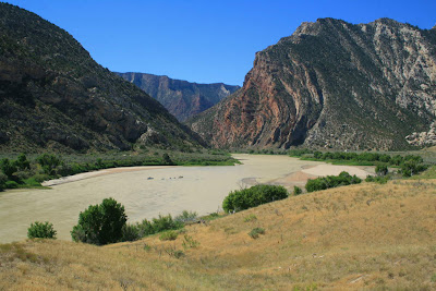
Today, the Gates of Lodore are one of the quintessential southwestern locales. Not many people visit this remote spot. BUt the National Park Service operates a primitive campground here and I can highly recommend a visit, even if you don't float the river. Note the subdued topography on top of the Gates and the deep defile that the Green River has cut.

Another trip launched before we did and I captured this pictures of their rafts heading south on the river. The entire trip through Dinosaur National Monument is only 45 miles but the variety of scenery is unimaginable.

Lee and Jaime Reznick paddle their canoes against the wind through the Gates. These rocks are part of the Precambrian Uinta Mountain Group and are about 1,000 million year old sandstones and quartzites. They are equivalent essentially to the Shinumo Quartzite in Grand Canyon.

The first major rapid is called Disaster Falls, named by Powell on his second expedition. This is where they wrecked one of their wooden boats (hence the name) and lost much of their gear and food. We would have a much better run with our rubberized craft and the guidebooks that helped us know where we were. Powell did not have such luxuries in his day but he did appreciate the geologic beauty he saw.

A view upstream on the Green River from Disaster Falls. The recent rains had made the river a brownish-red color.

August 9 - Here is a downstream view at the head of Triplet Falls in Lodore Canyon. A huge buttress rock is illuminated downstream and is composed of the Cambrian Lodore Fm. (more of which will be discussed later). Triplet Falls was formed when debris from a side canyon on the left (east) choked the river and caused it to shift towards the right wall, where rocks fall and further choke the channel.

Lower Triplet falls and some of the huge boulders that have fallen into the river from the west wall. The Uinta Mountain Group rocks are extremely durable and break only along fractures and joints and remain as obstacles to boating for a very long time.

This is the head of the rapid where debris has washed in from the east. It is a relatively straightforward run here with a little left turn down from here.

The last of the three major rapids is the aptly named Hell's Half Mile, another named by Powell. This is a telephoto shot of one portion of the rapid that is not runnable but rafters must be skilled in negotiating such treacherous waters.

Our group scouting the run in Hell's Half Mile. We spent the better part of 45 minutes here making sure we knew where to run. Everyone came through fine but there were many rocks in the channel.

View upstream on the Green River from our second camp at Rippling Brook. The river slowly turned from a vermilion-red color back to a dirty green color.

August 10 - Morning light shines on the unconformity that separates the Precambrian Uinta Mountain Group (lower, blocky cliffs) from the Cambrian Lodore Fm. (sheer-faced to stratified upper cliff). This unconformity represents 500 million years of time when erosion removed material from the ancient landscape. The Lodore Fm. is in every way similar to the Tapeats Sandstone in Arizona and the Flathead Sandstone in Montana. In fact, I just called these rocks "Tapeats" during our whole trip.

Ponderosa pines lined many portions of the Green River as seen here. Lodore is a deep and cool canyon most times of the year. In fact, the river freezes entirely during the cold winter months. This allows trees that are adapted to higher elevations to occupy these areas at between 5,500 and 5,000 feet. Douglas firs were also seen in profusion in north-facing cliffs near the river.

Note how the strata are steeply dipping into and beneath the river! The unconformity seen so high in the cliff face upstream from here is now diving beneath the river. The white cliff has exposures of the Madison Limestone, a Redwall equivalent in most respects.

We hiked up a short trail to a fantastic view upstream on the Green River. I am standing on top of the Lodore/Tapeats Sandstone and you can see how the layers in the rocks rise upwards in this direction.

Leif takes in the view upstream....

... and rafts float by us in the downstream direction.

This is a talus cone across from the overlook. Rockfalls cause boulders to become shattered into smaller pieces as they fall and the fractured debris is funneled into an apron on the beach.

As the sandstone descended beneath the river channel in a giant homocline, the next geologic unit appeared and it looks exactly like the Bright Angel Shale. It has the green
glauconite mineral that the Bright Angel has in the Grand Canyon. Oddly, workers here just call it the green shale beds of the Lodore Fm. I wonder if someone could come in here and give these rocks proper names! One shouldn't be surprised that the rocks here almost mimic those seen in the Grand Canyon for the Paleozoic - the paleogeography of the western US had a strand line of near shore environments from Sonora, Mexico to Alberta, Canada. These transgressing beaches stretch south to north and laid long lines of similar sediment.

Oh-oh! Somethings not right here - the rocks have been bent to an extreme angle! The boat is approaching the Mitten Park Fault which brings much younger rocks to river level. The scenery is about the change abruptly.

After passing the fault rafter enter Echo Park and exposures of the Weber Sandstone. This is the Esplanade equivalent up here in northern Colorado and Utah. Just after this photo was taken, a large rock fell off of the cliff and crashed near another boat in a different group. The wild Yampa river enters the Green just beyond the large rock and adds a different mix of sediment to the river.

This is Steamboat Rock that stands above the confluence of the two rivers in Echo park. Powell named it Echo Rock but the name did not stick. We stopped at a NPS campground hereto get drining water from a faucet. But the scenery was outstanding! Incredible to think that had the Echo Park Dam been constructed in the late 1950's, only the very tip of Steamboat Rock would have protruded out from the reservoir. Imagine 500 feet of water burying this view.

Rounding the bend around Steamboat Rock, the river crosses the Mitten Park Fault once again and strata are deformed wildly across the fault. This is the Pennsylvanian Morgan Fm., a series of alternating gray limestone and red sandstone that document a giant battle between terrstrial (sand) and marine (lime) environments. This is the point in North American geologic history when the seas gave way to the land and the outcome is displayed in the Pennsylvanian age rocks.

A backward glance at the upturned strata along the fault.

Entering Whirlpool Canyon, Jamie floats towards the Echo Park damsite (shadow, left) which would have been constructed within the Uinta Mountain Group and the Tapeats Sandstone. The story of this controversy is quite interesting and I read a book about it while floating the river. It is called, "Echo Park: Struggle for Preservation", by Jon Cosco. I can recommend it highly.

Here we see a 500 million year old landscape! Note the dark, blocky outcrops of Uinta Mountain Group on the left. Now see how lighter colored beds of the Tapeats Sandstone are exposed on the right. Having two units with such different characteristics is not the norm in geology, unless there is a fault that brings two rocks into contact with one another. Or... as in this case if an older rock was buried by younger sediment. That is what happened here - an ancient cliff was cut into the Uinta Mountain Group and this cliff was buried by sand about 500 million years ago. The evidience is right there along the Green River. You can even see the dip that was imparted in the sandstand as the waves washed up onto the cliff.

Here is another ancient cliff (river level) buried by younger sands (white, angled cap rock) in Whirlpool Canyon. Recent erosion has exposed the side of this ancient topography.

And another onlap feature at river level. The dark Uinta Mountain Group rocks were buried in lighter colored sandstone. Such features are common in the Grand Canyon as well and show the similarities between the two areas geologically.

August 11 - A rainbow above Jones Hole and the Madison Limestone.

The Green River flows up against an exposure of the Tapeats Sandstone.

August 12 - Sunrise on the Morgan Fm. and Weber Sandstone. The last day of our trip covered 18 miles and floated through many different kinds of scenery.

Approaching the exit of Whirlpool Canyon where the rocks dive steeply beneath the river once again, this time on the Island Park fault.

Looking upstream at the mouth of Whirlpool Canyon where the Weber Sandstone dives below the river. When these rocks here where folded into this position, they were still buried by thousands of feet of additional material that is now completely eroded away. Geologists (at least this one) often neglect to mention this important piece of the story. When the rocks we see today were folded, they were deeply buried. Recent erosion has exposed the core of these folds.

Joe at the oars in Island Park. I think most rafters just wish to "get through" Island Park because of the slow water and lack of rapids. But I found it just as beautiful as the canyons. And just as interesting.

Note the tilted strata in the distance. This is the Entrada Sandstone of Arches fame. However, note also that the unit is truncated flat on top of Diamond Mountain. This is an important piece of evidence for how the southwestern landscape evolved. Geologists are often confused and baffled at the way that rivers seem to ignore the modern topography. But evidence such as this (and found widely across the Plateau landscape) shows that before the deep canyons were cut, the landscape was rather flat and featureless. Perhaps 15 to 10 million years ago, the entire landscape near Dinosaur was floored by what is now the top surface on Diamond Mountain. Canyon cutting has dissected this surface and exposed the rocks within. Look!

A sharp bend in the river at the end of Island Park and into the Morrison Fm. The Morrison is the unit that holds many of the dinosaur fossils in the area.

A first view of our last canyon, Split Mountain Canyon. Here, the Green River enters Rainbow Park before running straight into an uplifted wall of rock. Relationships like these really puzzled John Wesley Powell (as they should any observant traveler). Why would a river flow into an uplifted wall of rock? It doesn't make sense. Unless you unravel the former landscape that used to exist here. As discussed in the previous section, when the river here was initially positioned in its course, the landscape was featureless on its surface. These folded rocks were buried beneath that surface and as the river slowly etched its way down into the landscape, it chiseled through the buried fold. Wow!

The entrance to Split Mountain Canyon from Rainbow Park.
Unbelievable!

Especially when you turn around 180 degrees from where the previous photo was taken and see the river in the wide open space of Rainbow Park.

Inside Split Mountain Canyon and a view to the north. The Morgan Fm. is in the lower half of the cliff, while the Weber Sandstone makes up the upper half.

The south limb of the Split Mountain fold. This is where our river trip ended on August 12. The Park City and Moenkopi formations are located in the strike valley that trends away from the camera. Massive Weber Sandstone on the left and a thin cap of Shinarump Conglomerate is on the right. What a setting.

A final look at the Green River downstream from Split Mountain. The river flows for many miles through the Uinta basin on its way towards Desolation and Labyrinth canyons. What a fantastic place Dinosaur is.
 August 8 - Morning light bathes the west wall at the Gates of Lodore in the northern part of Dinosaur National Monument.. We camped here before our river trip began and as we emerged from our tents, the rain clouds parted and a spectacular view greeted us. As beautiful as it is this is a confusing place because....
 ... when you turn your gaze upstream from the Gates of Lodore you see the wide open expanse of Brown's Park. This odd arrangement of landforms confronted John Wesley Powell when he floated through here in 1869 and 1871. Why did the Green River make a 90 degree turn to the south (away from the open valley) and enter a bedrock mass of hard Precambrian rocks? It can be difficult to understand but geologists explain it by invoking two rivers, the ancestral Platte and the ancestral Green. The ancestral Platte used to head east through Brown's Park but when it filled its course with rocky debris, its water spilled to the south and into a branch of the ancestral Green. In this way the two streams were joined and the modern Green River was born.
 Today, the Gates of Lodore are one of the quintessential southwestern locales. Not many people visit this remote spot. BUt the National Park Service operates a primitive campground here and I can highly recommend a visit, even if you don't float the river. Note the subdued topography on top of the Gates and the deep defile that the Green River has cut.
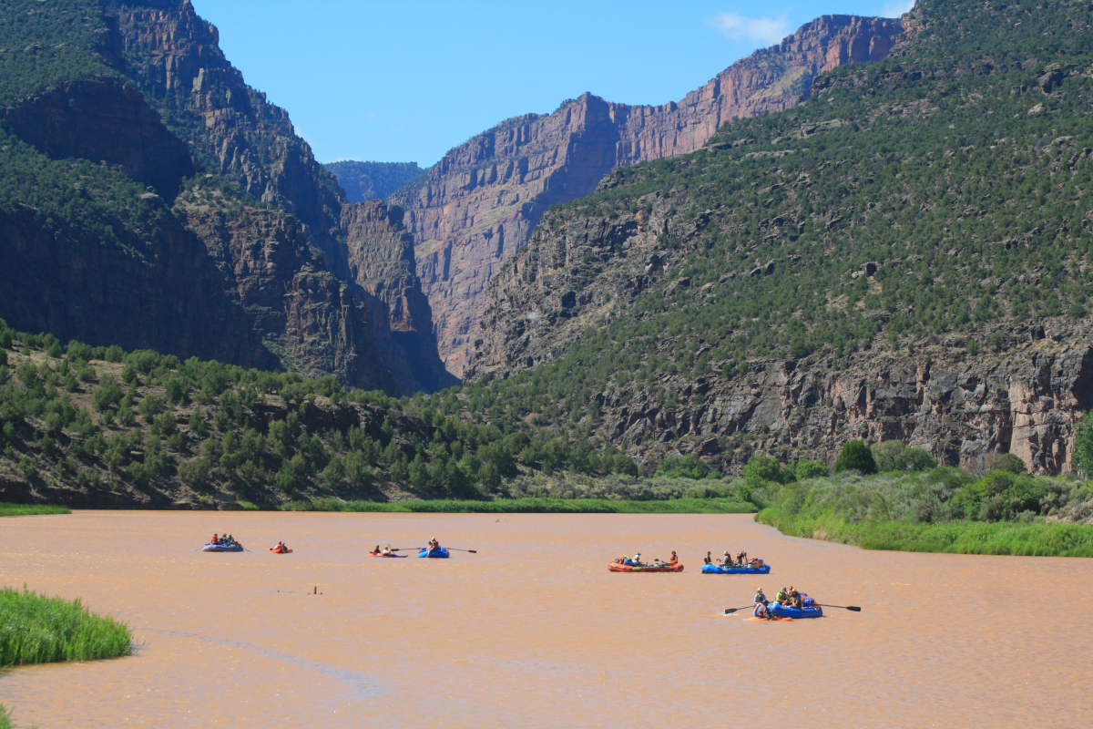 Another trip launched before we did and I captured this pictures of their rafts heading south on the river. The entire trip through Dinosaur National Monument is only 45 miles but the variety of scenery is unimaginable.
 Lee and Jaime Reznick paddle their canoes against the wind through the Gates. These rocks are part of the Precambrian Uinta Mountain Group and are about 1,000 million year old sandstones and quartzites. They are equivalent essentially to the Shinumo Quartzite in Grand Canyon.
 The first major rapid is called Disaster Falls, named by Powell on his second expedition. This is where they wrecked one of their wooden boats (hence the name) and lost much of their gear and food. We would have a much better run with our rubberized craft and the guidebooks that helped us know where we were. Powell did not have such luxuries in his day but he did appreciate the geologic beauty he saw.
 A view upstream on the Green River from Disaster Falls. The recent rains had made the river a brownish-red color.
 August 9 - Here is a downstream view at the head of Triplet Falls in Lodore Canyon. A huge buttress rock is illuminated downstream and is composed of the Cambrian Lodore Fm. (more of which will be discussed later). Triplet Falls was formed when debris from a side canyon on the left (east) choked the river and caused it to shift towards the right wall, where rocks fall and further choke the channel.
 Lower Triplet falls and some of the huge boulders that have fallen into the river from the west wall. The Uinta Mountain Group rocks are extremely durable and break only along fractures and joints and remain as obstacles to boating for a very long time.
 This is the head of the rapid where debris has washed in from the east. It is a relatively straightforward run here with a little left turn down from here.
 The last of the three major rapids is the aptly named Hell's Half Mile, another named by Powell. This is a telephoto shot of one portion of the rapid that is not runnable but rafters must be skilled in negotiating such treacherous waters.
 Our group scouting the run in Hell's Half Mile. We spent the better part of 45 minutes here making sure we knew where to run. Everyone came through fine but there were many rocks in the channel.
 View upstream on the Green River from our second camp at Rippling Brook. The river slowly turned from a vermilion-red color back to a dirty green color.
 August 10 - Morning light shines on the unconformity that separates the Precambrian Uinta Mountain Group (lower, blocky cliffs) from the Cambrian Lodore Fm. (sheer-faced to stratified upper cliff). This unconformity represents 500 million years of time when erosion removed material from the ancient landscape. The Lodore Fm. is in every way similar to the Tapeats Sandstone in Arizona and the Flathead Sandstone in Montana. In fact, I just called these rocks "Tapeats" during our whole trip.
 Ponderosa pines lined many portions of the Green River as seen here. Lodore is a deep and cool canyon most times of the year. In fact, the river freezes entirely during the cold winter months. This allows trees that are adapted to higher elevations to occupy these areas at between 5,500 and 5,000 feet. Douglas firs were also seen in profusion in north-facing cliffs near the river.
 Note how the strata are steeply dipping into and beneath the river! The unconformity seen so high in the cliff face upstream from here is now diving beneath the river. The white cliff has exposures of the Madison Limestone, a Redwall equivalent in most respects.
 We hiked up a short trail to a fantastic view upstream on the Green River. I am standing on top of the Lodore/Tapeats Sandstone and you can see how the layers in the rocks rise upwards in this direction.
 Leif takes in the view upstream....
 ... and rafts float by us in the downstream direction.
 This is a talus cone across from the overlook. Rockfalls cause boulders to become shattered into smaller pieces as they fall and the fractured debris is funneled into an apron on the beach.
 As the sandstone descended beneath the river channel in a giant homocline, the next geologic unit appeared and it looks exactly like the Bright Angel Shale. It has the green glauconite mineral that the Bright Angel has in the Grand Canyon. Oddly, workers here just call it the green shale beds of the Lodore Fm. I wonder if someone could come in here and give these rocks proper names! One shouldn't be surprised that the rocks here almost mimic those seen in the Grand Canyon for the Paleozoic - the paleogeography of the western US had a strand line of near shore environments from Sonora, Mexico to Alberta, Canada. These transgressing beaches stretch south to north and laid long lines of similar sediment.
 Oh-oh! Somethings not right here - the rocks have been bent to an extreme angle! The boat is approaching the Mitten Park Fault which brings much younger rocks to river level. The scenery is about the change abruptly.
 After passing the fault rafter enter Echo Park and exposures of the Weber Sandstone. This is the Esplanade equivalent up here in northern Colorado and Utah. Just after this photo was taken, a large rock fell off of the cliff and crashed near another boat in a different group. The wild Yampa river enters the Green just beyond the large rock and adds a different mix of sediment to the river.
 This is Steamboat Rock that stands above the confluence of the two rivers in Echo park. Powell named it Echo Rock but the name did not stick. We stopped at a NPS campground hereto get drining water from a faucet. But the scenery was outstanding! Incredible to think that had the Echo Park Dam been constructed in the late 1950's, only the very tip of Steamboat Rock would have protruded out from the reservoir. Imagine 500 feet of water burying this view.
 Rounding the bend around Steamboat Rock, the river crosses the Mitten Park Fault once again and strata are deformed wildly across the fault. This is the Pennsylvanian Morgan Fm., a series of alternating gray limestone and red sandstone that document a giant battle between terrstrial (sand) and marine (lime) environments. This is the point in North American geologic history when the seas gave way to the land and the outcome is displayed in the Pennsylvanian age rocks.
 A backward glance at the upturned strata along the fault.
 Entering Whirlpool Canyon, Jamie floats towards the Echo Park damsite (shadow, left) which would have been constructed within the Uinta Mountain Group and the Tapeats Sandstone. The story of this controversy is quite interesting and I read a book about it while floating the river. It is called, "Echo Park: Struggle for Preservation", by Jon Cosco. I can recommend it highly.
 Here we see a 500 million year old landscape! Note the dark, blocky outcrops of Uinta Mountain Group on the left. Now see how lighter colored beds of the Tapeats Sandstone are exposed on the right. Having two units with such different characteristics is not the norm in geology, unless there is a fault that brings two rocks into contact with one another. Or... as in this case if an older rock was buried by younger sediment. That is what happened here - an ancient cliff was cut into the Uinta Mountain Group and this cliff was buried by sand about 500 million years ago. The evidience is right there along the Green River. You can even see the dip that was imparted in the sandstand as the waves washed up onto the cliff.
 Here is another ancient cliff (river level) buried by younger sands (white, angled cap rock) in Whirlpool Canyon. Recent erosion has exposed the side of this ancient topography.
 And another onlap feature at river level. The dark Uinta Mountain Group rocks were buried in lighter colored sandstone. Such features are common in the Grand Canyon as well and show the similarities between the two areas geologically.
 August 11 - A rainbow above Jones Hole and the Madison Limestone.
 The Green River flows up against an exposure of the Tapeats Sandstone.
 August 12 - Sunrise on the Morgan Fm. and Weber Sandstone. The last day of our trip covered 18 miles and floated through many different kinds of scenery.
 Approaching the exit of Whirlpool Canyon where the rocks dive steeply beneath the river once again, this time on the Island Park fault.
 Looking upstream at the mouth of Whirlpool Canyon where the Weber Sandstone dives below the river. When these rocks here where folded into this position, they were still buried by thousands of feet of additional material that is now completely eroded away. Geologists (at least this one) often neglect to mention this important piece of the story. When the rocks we see today were folded, they were deeply buried. Recent erosion has exposed the core of these folds.
 Joe at the oars in Island Park. I think most rafters just wish to "get through" Island Park because of the slow water and lack of rapids. But I found it just as beautiful as the canyons. And just as interesting.
 Note the tilted strata in the distance. This is the Entrada Sandstone of Arches fame. However, note also that the unit is truncated flat on top of Diamond Mountain. This is an important piece of evidence for how the southwestern landscape evolved. Geologists are often confused and baffled at the way that rivers seem to ignore the modern topography. But evidence such as this (and found widely across the Plateau landscape) shows that before the deep canyons were cut, the landscape was rather flat and featureless. Perhaps 15 to 10 million years ago, the entire landscape near Dinosaur was floored by what is now the top surface on Diamond Mountain. Canyon cutting has dissected this surface and exposed the rocks within. Look!
 A sharp bend in the river at the end of Island Park and into the Morrison Fm. The Morrison is the unit that holds many of the dinosaur fossils in the area.
 A first view of our last canyon, Split Mountain Canyon. Here, the Green River enters Rainbow Park before running straight into an uplifted wall of rock. Relationships like these really puzzled John Wesley Powell (as they should any observant traveler). Why would a river flow into an uplifted wall of rock? It doesn't make sense. Unless you unravel the former landscape that used to exist here. As discussed in the previous section, when the river here was initially positioned in its course, the landscape was featureless on its surface. These folded rocks were buried beneath that surface and as the river slowly etched its way down into the landscape, it chiseled through the buried fold. Wow!
 The entrance to Split Mountain Canyon from Rainbow Park.
 Unbelievable!
 Especially when you turn around 180 degrees from where the previous photo was taken and see the river in the wide open space of Rainbow Park.
 Inside Split Mountain Canyon and a view to the north. The Morgan Fm. is in the lower half of the cliff, while the Weber Sandstone makes up the upper half.
 The south limb of the Split Mountain fold. This is where our river trip ended on August 12. The Park City and Moenkopi formations are located in the strike valley that trends away from the camera. Massive Weber Sandstone on the left and a thin cap of Shinarump Conglomerate is on the right. What a setting.
 A final look at the Green River downstream from Split Mountain. The river flows for many miles through the Uinta basin on its way towards Desolation and Labyrinth canyons. What a fantastic place Dinosaur is.


