Sunday, October 31, 2010

Evidence for October 6 Flagstaff Tornadoes

Addition to original posting:

On the same day that I took the photographs below (from near Kendrick Park), a National Weather Service aircraft took this aerial shot from southwest of Bellemont, AZ towards the northeast.


If you trace the line of these blow-downs you'll see that they trend between Kendrick Mt. on the center skyline and San Francisco Mountain on the right skyline.Therefore, these two parallel pathways are likely the southern portions of what I photographed on the ground farther northeast!

Original post:

You may or may not recall that northern Arizona and the Flagstaff area received national weather attention for a series of severe storms that raced across our region from north to south in the early morning hours of October 6. Perhaps 28 and at least 8 tornadoes were documented to have touched down in the area north and west of Flagstaff. While driving to and from the "Trail of Time Dedication" between Flagstaff and the Grand Canyon, I noticed unmistakable linear blow-downs of Ponderosa pine trees along US Highway 180 between here and the canyon. In at least three places the highway meanders across these awesome blow-downs. I stopped and photographed one of these sites on October 15, only 9 days after the event. The power of the wind on these huge trees is impressive!

Most of the blown down trees are splayed towards the north documenting the direction that the wind was traveling. Highway 180 is seen in the background. This particular site is only 2 miles south of Kendrick Park.

Trees were blown apart at the seams. I saw many instances of severs breakage on small pieces of trees.

A tangled mess for sure but by the time I shot these photos the US Forest Service had already been here to remove debris from the highway and from on top of fences.

The top of this tree was simply snapped and then blown about 50 feet away from its trunk.

Many trees were snapped well above their base and I could see that most were snapped towards the north.

I am sure glad I was not camping here when the tornado struck. It would have been like standing in front of a firing range.

This huge root ball was forced over and took considerable soil with it as it was raised.

This root ball lifted a fence from out of its place on the ground.

The roots were snapped on this tree as it fell over.

The storms of October 6 were intense locally but apparently not all that rare around here. Meteorologists say that an average of four tornadoes strike Arizona each year. This single storm well surpassed that average.

Saturday, October 16, 2010

'Trail of Time' Dedicated at Grand Canyon National Park

The Grand Canyon is the earth's single largest landform that speaks to the glories of earth history. Now Grand Canyon National Park has the largest geology exhibit in the world - the Trail of Time! On October 13, 2010, the trail was officially dedicated.

It was a fantastically beautiful day at the canyon with lots of sunshine, temperatures in the low 70's and a few white billowy clouds. The light was brilliant.

A crowd of about 120 people were in attendance at the west portal to the trail in front of the Verkamp's store.

Here is a close-up of the west portal to the TOT in front of the Verkamp's store. Note the familiar profile of the Grand Canyon cut into rocks that are actual samples of the rock layers they depict. That is Vishnu Schist representing the basement rocks of the canyon, with tilted Grand Canyon Supergroup rocks above them and horizontal Paleozoic strata capping the monument. There are four of these portals along the 2 kilometer long trail.

Here are some of the All-Stars who were in attendance for the ceremonies.

Steve Semken is a professor at Arizona State University and was one of the members who envisioned and worked on the Trail of Time design from the start.

Geologists George Billingsley and Sue Beard of the USGS, Flagstaff made the trip up to the canyon for the dedication.

And a picture of yours truly in front of the west portal.

Here is an example of one of the 13 signs that help explain the story of the Grand Canyon. This one tells the story of the youngest strata at the canyon, the Kaibab Limestone. I know that I will use this exhibit often in my many classes and tours that I run at the canyon.
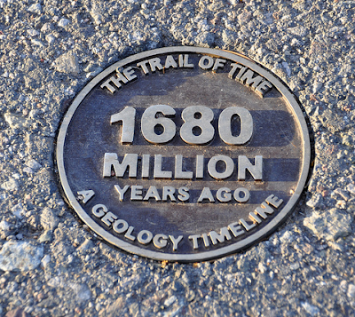
Photo by Mike Quinn of one of the trail medallions. These brass plaques are placed along the trail at ten meter intervals with each meter representing one million years. At the appropriate time marker, a rock sample or sign is in place to explain to visitors what this moment in time represents.

A visitor walks across the lithified bed of the Kaibab Sea along the Trail of Time at Grandeur Point.

One of the highlights of the TOT are actual rock samples that have been cut, polished, and placed on concrete pedestals along the trail. This example of Vishnu Schist shows spectacular folding within a dike of Zoroaster Granite.

Superintendent Steve Martin giving remarks at the dedication of the trail in front of the Verkamp's store.

Steve Martin and the entire design team on the rim of the canyon. From back to forward are Steve Semken, Karl Larlstrom, Laura Crossey, Mike Williams, and Judy Bryan (in ranger hat).

The design team - (left to right) Steve Semkin, Judy Bryan, Mike Williams, Laura Crossey, Ryan Crow, and Karl Karlstrom.

Arizona governor Jan Brewer sent the state forester to make a few remarks in her absence. She was most likely busy cutting funding for the state parks in Arizona or otherwise avoiding being seen in public for fear of a brain-freeze. Vote for Terry Goddard for Governor on November 2 to restore sanity to Arizona politics and governance!

Karl making remarks at the dedication. It was his vision beginning in 1995 that made the TOT a reality.

The National Park Service awarded Karl a Pendleton blanket with the image of the canyon as a way to say thank you for his outstanding leadership in making the trail a reality.

Judy Bryan stands in front of the west portal with a giant pair of scissors ready to cut the green ribbon.

And at 2:47 PM on October 13, 2010, the Trail of Time was open!

I didn't notice any champagne in the area but it was time of great joy at Grand Canyon.

Here is a close-up of the cut ribbon on a juniper tree.

Other guests at the event - (left to right) ranger Ron Brown, Richard Turner, Susan Schroeder, Martha Hahn, and Jan Balsom.


The official 'Trail of Time' logo. Next time you visit Grand Canyon check out the Trail of Time!

Friday, October 15, 2010

More "To-Hell-You-Ride", Colorado

Just a few more pictures from Telluride - remember that I forgot my camera so these were forwarded to me by Don Webster. These are from a drive and hike that we took up onto Wilson Mesa, southeast of the Historic District and in the Uncompahgre National Forest. You'd be hard-pressed to find anyplace with a more "Rocky Mountain High in Colorado" than this place!

Yep, those are the San Juan volcanics making those "stripes" in the snow up on Wilson Peak (elev. 14,106). They were erupted between 35 and 30 Ma in this part of the world.

Check out that old ranch. we walked down to it and it is still used but no one was around.

Mmm. Mmm!

Autumn, 2010


Sunday, October 10, 2010

Autumn in Telluride, Colorado

We experienced a fantastic autumn weekend recently in the Rocky Mountains! We stayed in a condominium in the old mining town of Telluride, nestled in a truly spectacular setting in a deep rocky bowl beneath Mt. Sneffels in the San Juan Mountains. The geology here is unbelievable. However, I forgot to bring my camera on the trip but ended up borrowing a friends to take a few shots. Have a look.

View towards the northwest from the St. Sophia Station on the inter-city gondola. Yes, inter-city gondola - Telluride is a very progressive city with a quite adequate tax base that funds the operation of this amenity. It connects the historic district in the valley with the new Mountain Village on the hill. We took the gondola to obtain the view above.

Wayne and Helen on the gondola up to the St. Sophia Station.

Our group posing in the brilliant sunshine of a Rocky Mountain autumn. Don and Anne (left); Bill and Beth (center); and Wayne and Helen (right).

Looking east into the enclosed bowl of the San Miguel River. You might be able to locate the huge Pandora mill building in the lower center of the photo. The majority of the rocks in this view are part of the San Juan volcanics that were erupted violently between about 35 and 30 million years ago. These volcanic deposits are composed mostly of andesite.

Looking north towards Dallas Peak (left, elev. 13,809) and Gilpin Peak (right, elev. 13,619). Both peaks tower above the Mill Creek Basin.

Close-up view of the Telluride historic district in the San Miguel River valley. Note the red and white sedimentary rocks exposed just above the townsite. The red strata belong to the upper part of the Cutler Formation (Pennsylvanian and Permian) and the Dolores Formation (Triassic). The Dolores Formation is equivalent to the Chinle on the Colorado Plateau. The whitish beds above the red beds are the Entrada Sandstone and the Wanakah Formation. Barely visible above these and near the top of the photo are thin beds of the Morrison Formation. To a Plateau geologist such as myself who is used to seeing these units much lower in elevation, it is incredible to see them here in an alpine setting.

View west towards Lone Cone in the far distance. Although having the shape of a large strato-volcano, the peak is actually just an erosional remnant capped by San Juan volcanics.

Another view to the west of Telluride and its mesa-top airport. It was difficult for me to ascertain what unit might be holding up Wilson Mesa on the left but it most likely is one of the Cretaceous sandstones of the Mesa Verde Group.

In places like Telluride, most people's attention is drawn towards the high peaks. This is normally what is deemed as unique and beautiful in such settings. However, what makes the peaks so attractive and eye-catching is actually the result of the extreme erosion which has deepened the valley's. A trip to this part of the world just 3 or 4 million years ago would reveal a landscape just as high as we see today but with much less topography (or vertical relief). The canyons would not be here! Extreme erosion has played just as important a role in developing this landscape as has the uplift and volcanism. I had this same observation while on the trek to the high Himalaya's in 2007. Our eyes are drawn to the peaks in such settings but the real story is in the depth of the valley's, which create the high peaks.

A view up canyon near Telluride. Note how the bedrock strata are tilted up towards the right (east) and become beveled and eroded in the center of the photograph. This beveling is the famous "Telluride erosion surface" which is a quite extensive surface that formed at the end of the Laramide Orogeny. After uplift of the western part of North America between 70 and 40 million years ago, extensive erosion beveled most of the countryside. The "Telluride surface" has been observed as far north as Washington state! You might be able to notice a steep cliff immediately above the two white patches of strata in the right center of the photograph, capped by a dark layer. This cliff, about 150 feet high, is located beneath the pyramid-shaped bluffs carved in the San Juan volcanics. This cliff is composed of the Telluride Conglomerate, deposited as outwash from a former highland on top of the planed Telluride surface.

A remnant of the Telluride Conglomerate pokes above the trees at the St. Sophia station near Telluride Mountain Village.

We walked down one of the ski slopes from St. Sophia Station and got one final look at this unbelievable setting. I hope you have enjoyed this small tour of the upper San Miguel River valley.