Helen and I were recently able to visit Death Valley National Park in California and it turned out to be a fantastic trip with early spring season wildflowers.
This is one called
Desert Gold - a member of the sunflower family (
Garaea canescens) and by far the showiest player in the show.
On the southern drive toward Saratoga Springs.
I'm not a photographer of flowers but it was easy to at least get some of them in the picture.
See what I mean.
This is
Five-spot - (Nemophila maculate) and it too was putting on another strong showing.
We drove west from Las Vegas and soon entered the Amaragosa River Valley near Shoshone in easternmost California.
In a road cut just about 4 to 5 miles east of Shoshone, we encountered a dark band of rock. A closer inspection proved that it was obsidian embedded within volcanic tuff. The interpretation here is that after emplacement of the tuff, the center of the deposit was squeezed into obsidian.
A fault offsets the volcanic beds to the east of the obsidian outcrop.
Close-up of the ash-fall tuff. These volcanic deposits are from an Oligocene outburst of acidic volcanism in central Nevada and this volcanic event formed much of the ore that is mined in Nevada (which currently produces about 80% of the US gold production).
The Amaragosa River - with water in it!
Be sure to visit the Shoshone Museum on the main highway.
It has a collection of Death Valley rocks laid out in a time-line with explanations on them.
Most tourist information highlights the Opera House where we enjoyed a picnic lunch.
Wind-storm on Pyramid Mountain near Shoshone.
Our first stop within the national park was
Dante's View at an elevation of 5,476 ft. above sea level. Badwater on the floor of Death Valley (seen here at the bottom of the photograph) is at an elevation of -282 ft. Therefore, it is well over one mile to the floor of the valley below. And Telescope Peak across the view in the Panamint Mts. is at 11,331 ft. above sea level, making it almost twice as high as Dante's View. That means the alluvial fan coming out of the mountain front across the way descends for a mile to the valley floor. Two Grand Canyon's stacked on on top of the other would fit easily in the Panamint Mt. front in this view. Death Valley is a geologists paradise!
View to the north from Dante's View into Death Valley. Death Valley is variously described as a rift valley, a graben valley, or a pull apart basin. Take your pick - the earth's crust here is being subjected to tensional stresses which lowers the valley and raises the mountains.
This basin began forming some 25 million years ago and sediment began to wash into it. Some of these sediments and their later counterparts are now being eroded into colorful hills, as seen here at Zabriskie Point.
That is the point out there in the upper left of the photograph and the tilted sediments are part of the Miocene-age Furnace Creek Formation. These deposits were filling an earlier version of Death Valley but later stretching of the earth;s crust tilted the deposits. For a full listing of Death Valley rock units,
see this National Park Service web site.
Okay - it is the artistic element in me that initiated this artful attempt. We were here at a great time of day for the light!
More color from Zabriskie Point.
The Mesquite Dunes near Stovepipe Wells. We did a short hike here to see some eolian features.
Ripple marks on top of larger ripples.
The overall wind pattern in this part of Death Valley is from north to south (left to right in this east view). However, the most recent wind system has put ripples opposite to this such that the windward side of the small ripples is from the south (right) with the lee side to the north (left). Note the corniche-like feature on the crest of the dune.
Jack and Helen checking it out.
Close-up of the highest dune with the Grapevine Mts. in the background.
Next up was Mosaic Canyon, a beautiful little slot canyon in very old rocks. Note the cemented Pleistocene gravel still stuck on the right side of the canyon wall in the background.
A close-up of this gravel reveals the origin of the name "Mosaic."
The bedrock lithology here is called the Noonday Dolomite, a Neo-Proterozoic carbonate unit. In the canyon walls, it was polished to nearly a marble.
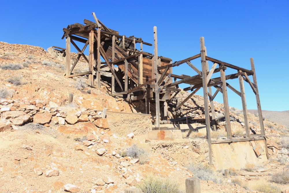
The
Eureka Mine in the Panamint Mountains. This was a gold prospect in which over $175,000 of ore was taken out in the first half of the 20th century.
The quintessential California desert scene.
A fantastic viewpoint of Death Valley from the top of the Panamint Mountains.
Note the tilt to the strata - as the Panamint block is stretched, the once flat-lying rock layers rotate.
This is a view of the Furnace Creek alluvial fan from Aguereberry Point. The grove of green trees at center left is the Furnace Creek Ranch area. The Furnace Creek Inn complex is smaller and located center right near the top of the fan.
We could also look northwest and see the High Sierra.
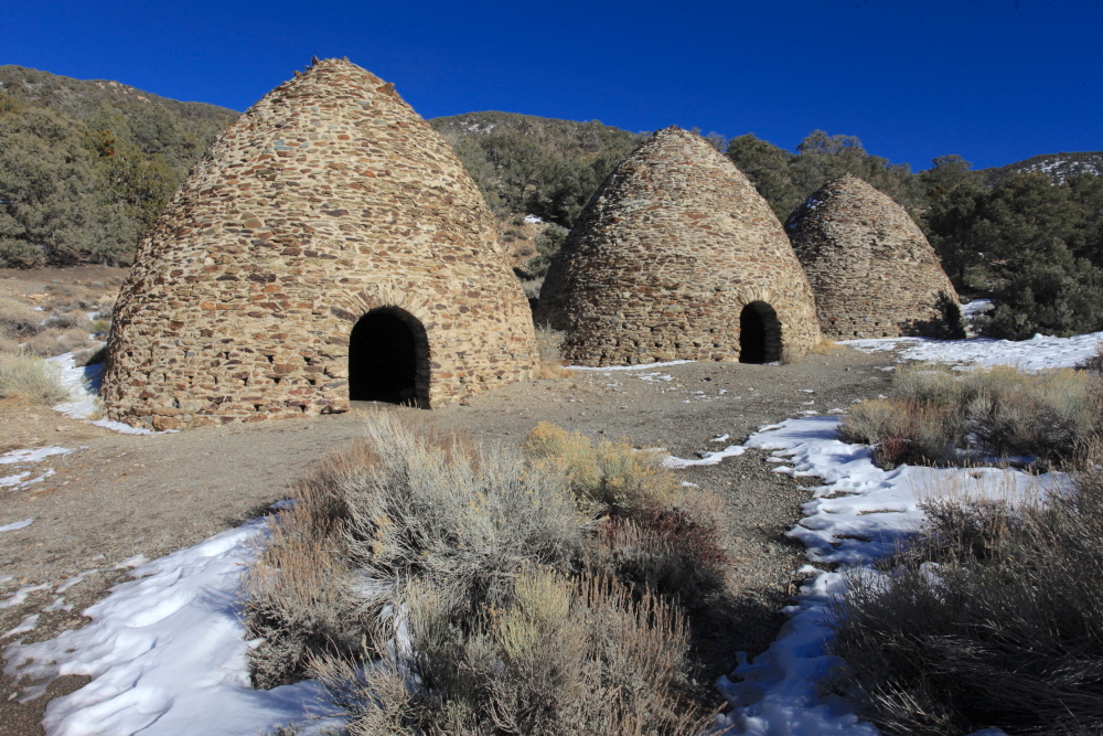
These are the famous charcoal kilns, built in 1879 to make charcoal for a nearby mine.
Pinyon pine trees were cut here and then placed in the kiln for about two weeks to make charcoal. The kilns were restored once in the 1930's and again in the 1970's.
In far western Nevada is the ghost town of Rhyolite. This gold camp once held 8,000 citizens - for a few years. When the gold played out, the town died.
The old Union Pacific train station is similar to one built at the same time in a sleepy hamlet named Las Vegas, Nevada.
A former bank building stands in ruins.
Many of the buildings are built with blocks of rhyolite rock - the host rock of the gold.
This is the 26-mile long Titus Canyon Road. It is a one-way track that leads to spectacular scenery. The canyon leading down to the right is Titanothere Canyon, where Donald Curry found an Oligocene fossil of the same name.
This is a conglomerate member of the Titus Canyon Fm., an Oligocene deposit laid down in a swamp and savannah environment.
The lower end of the Titus CanyonRoad is in and interesting slot canyon composed of auto-breccia in the Bonanza King Fm.
And suddenly, the road emerges from the mountain front and onto an alluvial fan. The Northern Death Valley fault zone runs along the base of the mountain.
Recent cosmogenic helium work has shown that Ubehebe Crater was formed as recently as 800 years ago when magma rose up into the local water table creating a phreatomagmatic eruption.
Beautiful stratified volcanics in the walls of the crater.
Northern Death Valley.
The nine-mile-long Artists Drive.
The Artists Drive Formation is a Pliocene-age valley fill deposit.
Crusty salt deposits on the floor of the valley.
Note the recent fault scarps near the apex of the alluvial fan near Badwater. These are suspected to be 1,000 year old.
Badwater - the lowest spot in North America at -282 ft.
Salt pan at Badwater.
Our last stop in Death Valley was at the south end of the Harry Wade Road at Saratoga Spring.
This large wetland was truly unexpected and here we saw one of the species of desert pupfish.
Death Valley is one of the great landscapes in North America. In some ways, I wish it had a different name - its current name was so momentary of an event in its history. The name is colorful for sure but the connotation does not reveal just how much there is to see here.