Whew! The trip in South America was quite hectic but being at home is no less so - just familiar terrain. Enjoy these photos from a seven-hour flight from the southern tip of the continent to La Paz, Bolivia.
This is Morro Chico (Little Rock) a volcanic neck about 12 million years old. There are four other necks nearby along the road from Puerto Natales to Punta Arenas. Volcanic necks are the remains of a volcano -specifically the root or conduit where the lava moved toward the ancient surface,
In the air again! I love these flight. This time it was a scenic flight over the southern Patagonia region of western Argentina and eastern Chile. This is Lago Argentina, one of many glacially carved depressions in this part of the world. Some are filled with sea water (fjords) farther west and some like this do not have a connection to to the sea and are filled with fresh water.
This is the next big lake to the north called Lake Viedma. Note the spine of the Andes Mountains beyond and the large glacier spilling out of them toward the east. Clear days like this are very rare in this part of the world.
Zooming into Mt. Fitzroy. These towers are a beacon to rock climbers and it was in this area that Yves Chouinard got the idea for the name of his outdoor clothing company, Patagonia. The granite spires belong to part of the intrusive event that also occurred at Torres del Paine to the south of here.
This is quite a bit farther north in Argentina and these are likely
kettle lakes. One of the big frustrations in these flights is that sometimes huge weather systems cause clouds to block our view and we miss seeing huge swaths of the landscape. This si not so far north that the glacial evidence in Patagonia is is completely behind us however.
Another set of clouds obscured our view, I gave a lecture and by the time I returned to my seat we flying past
Anconcagua, the highest mountain in the world outside of Asia, and thus the highest peak in the Western and the Southern hemispheres. It lies entirely within in Argentina but we are flying over Chile and looking to the east. Winter snow still blankets the lower elevations beneath the peak.
Just off the coast of northern Chile and southern Peru I spied the edge of huge band of clouds that stretched in the Pacific Ocean as far as the eye could see. Note the shadow cast by these clouds on the Pacific. As we landed briefly in Lima Peru, we descended through the cloud layer and when I asked our Captain how high was the blanket he told me it was 2,500 feet above sea level. The distance from the cloud to the sea here is 1/2 mile.
The next morning we were exploring the capital city of Bolivia, La Paz. What a truly unique setting for a city of two million people.
This area is right in the city and is called the Valle de Luna (Valley of theMoon). These are relatively recent volcaniclastic sediments (rocky debris and dirt composed of volcanic rocks) that is being rapidly eroded.
A hoodoo capped by a boulder in the Valle de Luna in La Paz Bolivia.
Look at the city as it grows up the slope of this giant arroyo cut into the edge of the
Altiplano. The plateau top here is the edge of the Altiplano and the city has grown up onto and beyond onto the plateau.
Dense city cluster to the top of the Altiplano. The part of the city of La Paz on top is known as El Alto.
Growth of the city over the unconsolidated sediments. See an interesting article
here about La Paz.
Mount Illimani at 21,122 feet above sea level is a dramatic backdrop to the city.
The national soccer stadium where many a South American football player comes to gasp for air. The stadium is at about 11, 932 feet above sea level.
La Paz does have a Colonial-era heart and the narrow streets are like many in South America.
The Plaza Mayor in central La Paz with the traditional flag (barely visible) behind the newest flag of the country, called whipala, which represents the loose amalgamation of indigenous nations. Seean interesting story behind this flag
here.
Look closely at the clock on this government building - it is backwards with the 1, 2 and 3, o'clock hours on the left side. More background on all of this
here.
Colorful street scene in old La Paz. The wall art is incredible and this man sleeping next to it was too rich to pass up.
An Amarya woman walks past the wall art.
Weaving seen in the store of a street vendor. It is a very colorful city.
A series of telefericos (gondolas) are part of the public transport system and we got to ride one to the top of the Altiplano. An interesting solution to the horrific traffic that clogs the streets.
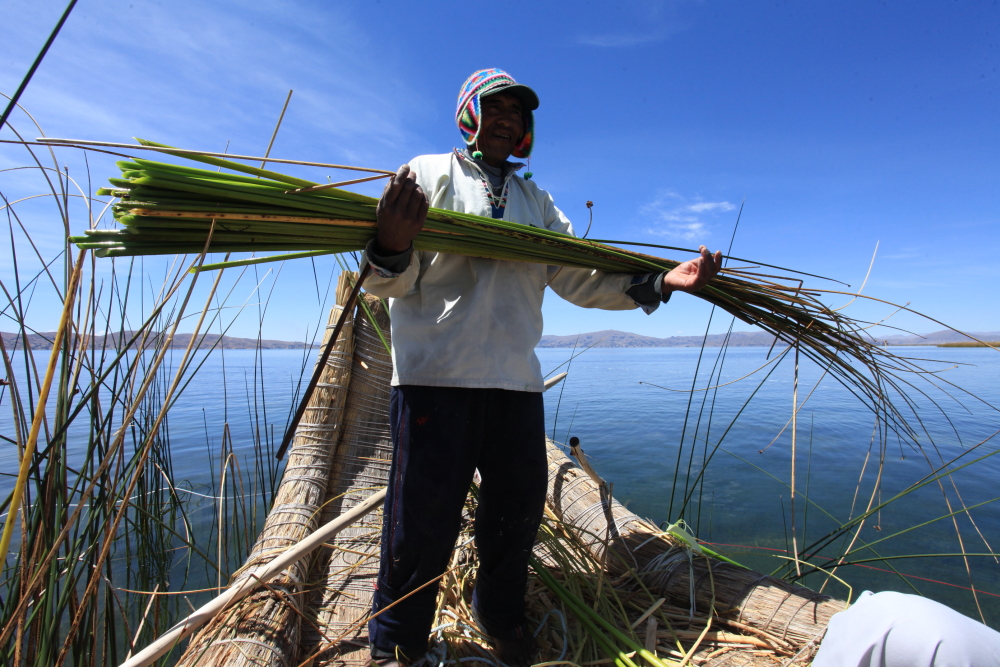
Fantastic clouds seen on our way to Lake Titicaca across the Bolivian Altiplano. This was a dream come true for me to visit the lake and see the Altiplano. My last blog posting from this trip will be about the lake.