Three river trips in Grand Canyon and a quick trip to Hawaii - all between April 17 and May 28. Whew! That was a whirlwind 41 days but all of it great fun, great work and now complete. I get a few weeks off before venturing to Iceland with Smithsonian Journeys on June 15.
This last river trip was quite special as it included alumni from the
Geology Program at Northern Arizona University. In all, we had 15 alumni and two current professors in the program. It was a thrill to be able to discuss the geology of the Grand Canyon in such depth - those who graduated from the program as early as 1971 have not lost any interest in the subject. It was great to meet those who came before me, as well as those who came after. This is sure to become a biennial affair.
Friday morning, May 20 - it snowed all night in Flagstaff. While not impossible for this time of year, in Flagstaff, it was pretty late in the season for even a dusting of snow. What a way to begin the trip.
The trip was designed with a full day field trip on the way up to Lees Ferry. The first stop was at a viewpoint for Sunset Crater and the San Francisco Peaks. As I exited the van, someone said, "What can you teach me about the Peaks that I don't already know?" Oh boy, I thought. This could be a tough day. But it turns out that there was plenty to share about recent discoveries. Here Professor Ryan Porter speaks about southwestern tectonics as it relates to the San Francisco Volcanic Field.
We also discussed how Basin and Range thinning of the crust might be causing hot asthenosphere to eat away at the lower crust beneath the southwestern edge of the Colorado Plateau. Turns out there was lots of new stuff to engage in and we had to cut it short with all that was planned for the day.
I have always wanted to view the Grand Canyon from the top before embarking on a river trip and this field trip allowed me to do just that. We even saw two boats on the river as we enjoyed lunch here. We also stopped in the Painted Desert to view a petrified stump in the Chinle Formation before overnighting at the Cliff Dwellers Lodge near Lees Ferry.
The amount of beer and wine brought on this trip was impressive and reminded me of the geology field trips that we used to take in the 1970s and 1980s.
Our boatmen had to rearrange some other gear to make room for it all. It was going to be hot out and we were going to be thirsty.
After leaving Lees Ferry, we passed the contact of the Toroweap Formation (above) and the Coconino Sandstone (below). Christine Turner (1974) did her Master's work on the Toroweap Fm. and it received the most love it ever has since she completed her thesis.
Small slump block along the river.
Which way does the Colorado River go? Even with all of these trained geologists, the answer to that question came out the same as it always does - about 50-50. But the river goes left here with Soap Creek coming from the right. Soap Creek is one of the north-directed tributaries in this part of the Grand Canyon.
Clear, cold water. A treat on a hot day.
Note the channel-form in the photo (center), cut within the Supai Group of rocks.
Our first hike was up in North Canyon. Dick Leigh (1971) was constantly amazed at the geology for the entire 10 days.
Looking down-canyon from the reflecting pool, one can see how the massive Supai sandstone body fractures by exfoliation. Note how the fractures parallel the walls
and the floor of the canyon. As the material is eroded away, confining pressure is released within the rocks and they "pop" out slightly to give this pattern.
Our first night's chair circle. Each night someone took a turn after dinner with a geologic theme talk.
In the mornings before we launched, the geologic maps were laid out to discuss the days sights and hikes. Here Professor Mike Smith talks over some Ron Blakey paleogeographic maps.
A cavern in the top of the Redwall Limestone filled and chocked shut with its own rubble.
Staining on the Redwall facilitated by run-off from the red layers above.
A fossil of a nautiloid in the Redwall.
\
Giant, dog-tooth spar crystals near river mile 35. These calcite crystals are about 14 inches long.
All the way down in the Devonian Temple Butte Limestone. Here a channel has been incised into the underlying Muav Limestone and filled by the purplish beds of the Temple Butte.
This rockfall at river mile 42.5 occurred in the winter of 2011-2012 with quite a debris field all the way to the river.
Reflections near river mile 43.
Steve Scott and Marvin Glotfelty yuck it up in camp.
Our crew with Colorado River and Trail Expeditions was awesome (as usual). From left to right, John Toner, lead boatman; Mikenna Cloakey, boatman, Tristan Helzer, swamper, and Tony Williams, swamper. (Note: a swamper is a deck-hand to a river boatman, although in Tony's case, he easily is as knowledgeable as any boatman about the Grand Canyon).
This large rockfall in Saddle Canyon is in the process of being removed by the stream - note the steep wall just below the large boulder that is created by stream erosion. This rockfall has dammed the side stream, which was in place long enough to completely fill with sediment behind it.
Travertine fill occupying side drainages within the Bright Angel Shale. Preliminary dates on the travertine are about 330,000 years ago.
Reprecipitated calcium carbonate mud in the bed of the Little Colorado River.
Reflections at the confluence of the Big and Little Colorado rivers.
Boxonia stromatolite fossil on the beach at Carbon Creek.
The NAU Geology Alumni in Carbon Canyon. Oldest Alumni from left to right (front): Dick Leigh (1972); David Saunders (1971); Tom Daneker (BS 1972 and MS 1975); Christine Turner (1974); Bob Broomhall (1978); Steve Scott (1979); Jeffrey Barnhill (1979); John Noll Jr. (1981); (middle row) Don Hanson (1980); Marvin Glotfelty (BS 1977 and MS 1985); Wayne Ranney (1980 and 1988); Kent Norton (1990); Rick Leone (1991); Amy Wolkowinsky (Instructor); Chris Schick 2006); (back row) Professor Mike Smith, Sedimentology and Stratigraphy; Professor Ryan Porter, Tectonics/Structural geology.
Examining the upturned beds of the Tapeats Sandstone in Carbon Canyon along the Butte fault.
Hiking in the wide expanse of the Hilltop Ruin area at river mile 72. View to the southwest. The hill is capped by far-traveled Colorado River cobbles and gravel, which in turn are overlain by local landslide deposits. At about 400 feet above the river, these river cobbles may have been deposited about one million years ago when the river had only incised to this level.
Christine became a mentor to young Tristan who is 19 years old. He certainly got a fill of geology on this trip which may influence his major at the University of Utah.
We hiked up Seventy-Five Mile Canyon to see these spectacular water escape structures in the Shinumo Sandstone. These were once flat-lying beds of sand that were disrupted, perhaps when an earthquake jostled the land causing the water in the sand to escape upwards. Tom Daneker had studied the Shinumo Sandstone for his thesis work in 1974.
David Saunders (1972) recently retired from Pioneer Natural Resources and shows off his Lumberjack pride. Pioneer has graciously supported the NAU Geology Department through the efforts of David and helped make possible Dr. Ryan Porter's participation in the trip.
Getting wet in Sockdolager Rapid!
The view from Christmas Card Point looking east toward the Powell Plateau. Those are our two boats at the Deer Creek Falls beach below.
We did a hike/swim at Matkatamiba Canyon. I would guess that I only stop at this canyon once every ten trips. It is a beautiful side stream carved within the Muav Limestone.
Clear pool in Matkatamiba Canyon.
Green reflections in Matkat.
Maidenhair ferns (
Adiantum capillus veneris) in Matkat.
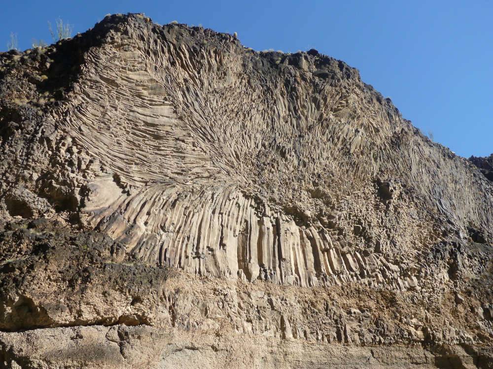
As if seeing the Grand Canyon in its entirety is not enough, the canyon then displays phenomenal evidence for when volcanoes erupted within and upon the rim of the canyon! Here a fantastic display of columnar jointing is exposed near river mile 185.
Mike Smith (left) draws diagrams for Ryan Porter at the evening theme talk on Colorado Plateau uplift.
Fluting in the granite walls of the Lower Gorge in Grand Canyon.
Drums by Gervasio Barzola (Pioneer Natural Resources) and guitar by Mike Smith (NAU Geology).
Farewell dinner on the river. This trip was a great success on all counts and I'm sure that NAU Geology will want to run this trip again. Right now there is talk of a Canyonlands river trip in 2018. More information to follow.