This past weekend, I was asked to take part in a Japanese TV production at the Vermilion Cliffs, a remote location in far northern Arizona. I was asked to serve as geologic interpreter for
the longest running Japanese TV Travel Documentary program, titled “Sekai Fushigi Hakken (Discover the Wonders of the World), which has been airing in Japan since 1986. This is my second Japanese television project I have worked since last November. I was to explain how this extraordinary landscape came to look the way it does.
Setting up the initial shots. We had to drive for 90 minutes on a very bad road just to attain the trailhead. Then it was a short walk into the rocks.
This was the host of the show who was in front of the camera explaining the geology.
The area boasts some of the strangest forms I have seen in sandstone outcrops and it is easy to see why they wished to film here.
There are lots of exposures of Navajo Sandstone in the Arizona and the American Southwest. But I think they were drawn to this particular area because of the fantastic shapes, which can be explained geologically.
To start with, the Navajo Sandstone was deposited during the Jurassic, about 190 million years ago. It's obvious textures show that this part of North America was a vast Sahara-like desert in which huge dune fields abounded. These are essentially petrified dunes.

Close-up of the cross-bedded sandstone. Cross-bedding indicates the current direction - in this case air or wind. The direction that the cross-beds dip indicates the ancient wind direction. Here we can see that the wind was blowing from left to right. It is the leeward side of the dunes that are preserved. The US quarter for scale lies within a bed of sand that has variable grain sizes, while the thin wisps that stick out in relief are of one particular size. The interpretation is that variably-sized layers resulted from sand avalanches that slid down from the crest of the dune. In these avalanches, variably sized grains intermix. (See the picture immediately below). The thinner but single size layers are the result of gentle winds blowing across the dune face in between avalanches. The wind segregates the sand grains to a particular and specific size. As all of this texture sits buried, groundwater moves through the sand and leaves variable amounts of cement, ultimately causing this feature when the rock becomes uplifted, exposed and weathered. This was quite a bit of information to relate to a travel variety show but our host was most gracious and seemed to be impressed with the information (relayed through a translator).

The next two photos are from the Namib Desert in southern Africa. This one shows the extent of this great desert, which makes for a good modern analog of the Navajo erg (sand sea) that was present in the American Southwest during the Jurassic some 190 million years ago.
Here are examples of sand avalanches from the dune field in Namibia, with sand avalanches seen on the leeward side of a dune. Note the tongues of sand that have naturally cascaded downhill when the slope of the dune became too too steep.
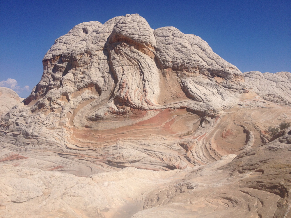
And all of this is just the first part of there story! The previous could explain most Navajo Sandstone outcrops anywhere on the Colorado Plateau. Here in the Vermilion Cliffs however, a few beds of sandstone were involved in a prehistoric landslide that disrupted the layering before they became cemented. In the middle of this rock, you can see the reddish contorted beds riding up and over the in-place beds below and above. This is what gives this area its unique attraction.
Close-up view of the mobilized bed of sand (main part of the picture with brownish rock) with an intact and undisrupted cross-bedded sandstone riding on top of it (upper left). Note the clast of cross-bedded sandstone (lower right) that was broken off from its main counterpart and lodged as a separate clast within the disrupted beds.
Overturned sandstone involved in a Jurassic-age slump event. The slump could have been initiated by an earthquake or slippage along a wet horizon (or both).
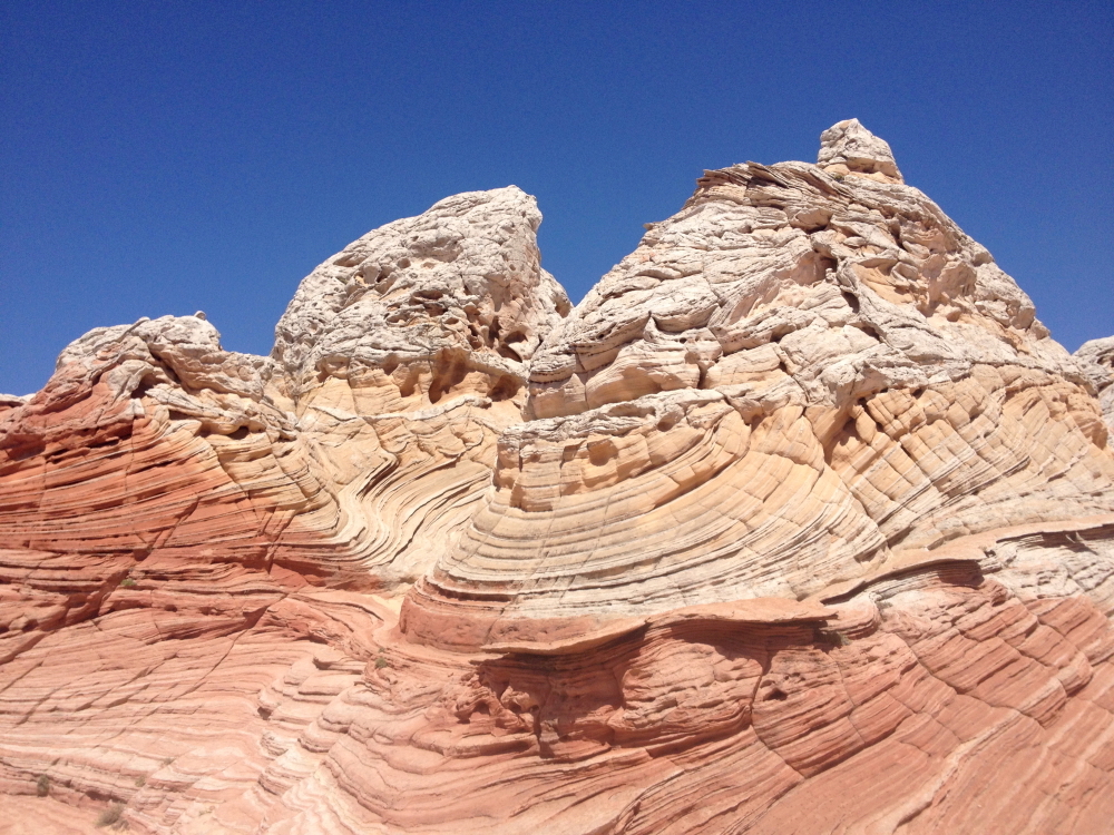
Small-scale faults disrupt the cross-bedding. Features like this suggest that the sediment was somewhat consolidated and partially brittle. The extreme folding elsewhere indicates that it was not completely lithified.
A plant called
rockmat (
Petrophytum caespitosum) in the Rose family, grows where water seeps out of the rocks and adds a touch of green to an otherwise red landscape.
The mobilized bed appears as whitish sandstone on the very top of this outcrop with partially faulted and bent layers below.
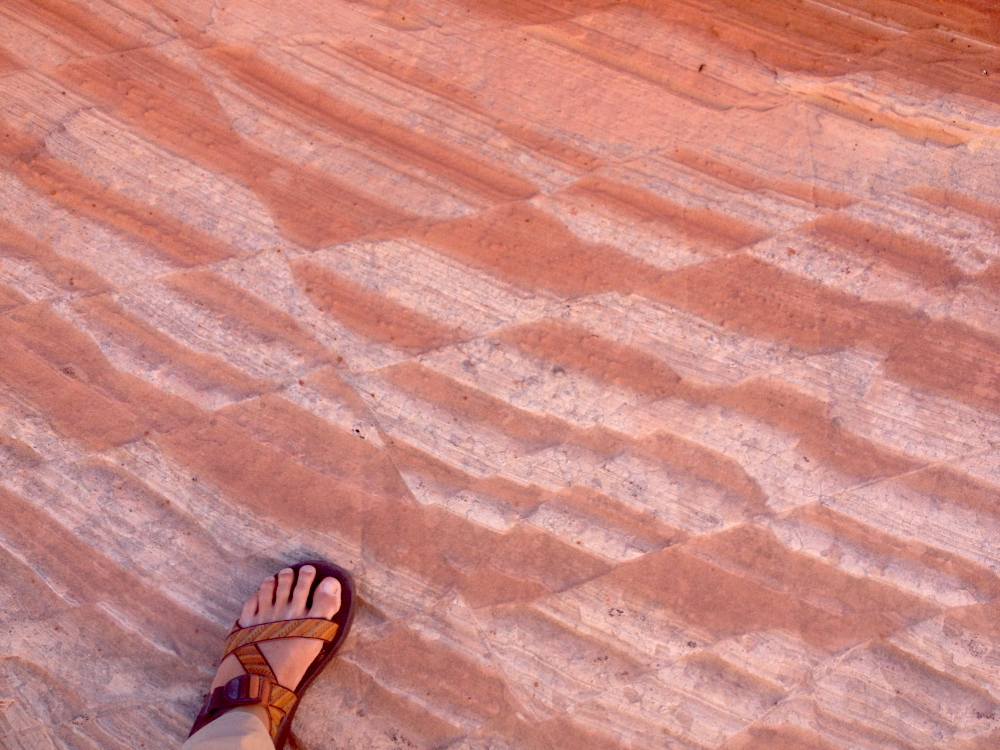
Another great feature of the area is the polygon in the sandstone. Many of these are pentagons or hexagons and are reminiscent of the columnar jointing found in basalt rocks. These however are not cooling fractures but form from the expansion and contraction of the sandstone surface or shrinkage related to the inclusion of clay grains in the sandstone (the former cause is more likely in this case). Here we see polygons within polygons.
I often refer to these textures as "biscuit" rocks, since they appear like a pan of freshly cooked biscuits.
Don't forget the
B roll!
The host walking on the biscuit rocks.
This was an enjoyable project to work on and I am thankful for TV-man Union in Japan for using my services. The feature will air in Japan on September 23 at 9 PM.